GPS trackers have become ubiquitous in modern life – from finding your lost phone to tracking delivery trucks, monitoring elderly relatives, and recovering stolen vehicles. But how does a small device know exactly where it is on Earth? This comprehensive guide explains the technology, components, types, and applications of GPS tracking systems in plain English.
🛰️ GPS Basics: The Foundation
What is GPS?
GPS stands for Global Positioning System – a satellite-based navigation system originally developed by the U.S. Department of Defense in the 1970s and made available for civilian use in the 1980s.
Key facts:
- Constellation of 31+ satellites orbiting Earth
- Satellites orbit at approximately 12,550 miles (20,200 km) altitude
- Complete orbit every 12 hours
- Positioned so 4-12 satellites are always visible from any point on Earth
- Operated by U.S. Space Force
- Free to use worldwide (no subscription for GPS signals)
Similar systems worldwide:
- GLONASS (Russia) – 24+ satellites
- Galileo (European Union) – 30 satellites
- BeiDou (China) – 35+ satellites
- QZSS (Japan) – Regional system
- NavIC (India) – Regional system
Most modern GPS trackers use multiple systems simultaneously for better accuracy and reliability.
📡 How GPS Positioning Works: The Core Principle
GPS positioning relies on a concept called trilateration – determining position by measuring distances from known reference points.
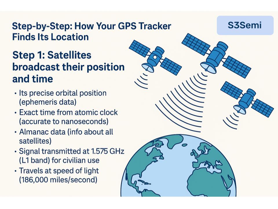
Step-by-Step: How Your GPS Tracker Finds Its Location
Step 1: Satellites broadcast their position and time
- Each GPS satellite continuously broadcasts:
- Its precise orbital position (ephemeris data)
- Exact time from atomic clock (accurate to nanoseconds)
- Almanac data (info about all satellites)
- Signal transmitted at 1.575 GHz (L1 band) for civilian use
- Travels at speed of light (186,000 miles/second)
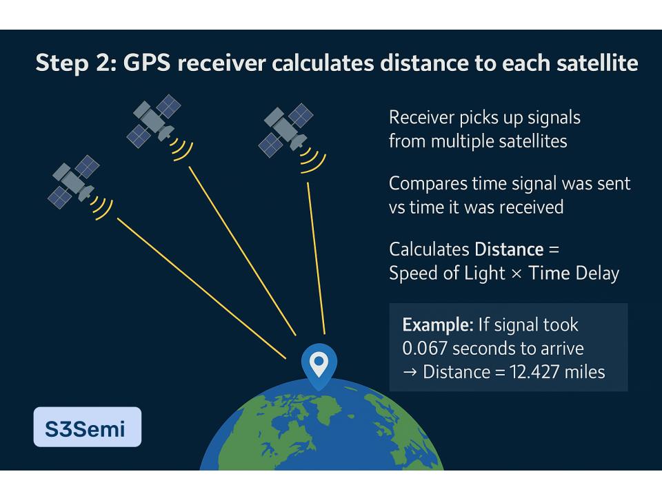
Step 2: GPS receiver calculates distance to each satellite
- Receiver picks up signals from multiple satellites (minimum 4 needed)
- Compares time signal was sent vs time it was received
- Calculates distance: Distance = Speed of Light × Time Delay
- Example: If signal took 0.067 seconds to arrive → Distance = 12,427 miles
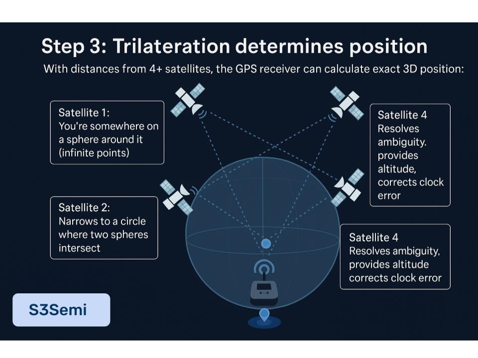
Step 3: Trilateration determines position
With distances from 4+ satellites, the GPS receiver can calculate exact 3D position:
Why 4 satellites minimum?
- Satellite 1: You’re somewhere on a sphere around it (infinite points)
- Satellite 2: Narrows to a circle where two spheres intersect
- Satellite 3: Narrows to two possible points
- Satellite 4: Resolves ambiguity, provides altitude, corrects clock error
What you get:
- Latitude (north-south position)
- Longitude (east-west position)
- Altitude (height above sea level)
- Time (extremely accurate – used to sync device clocks)
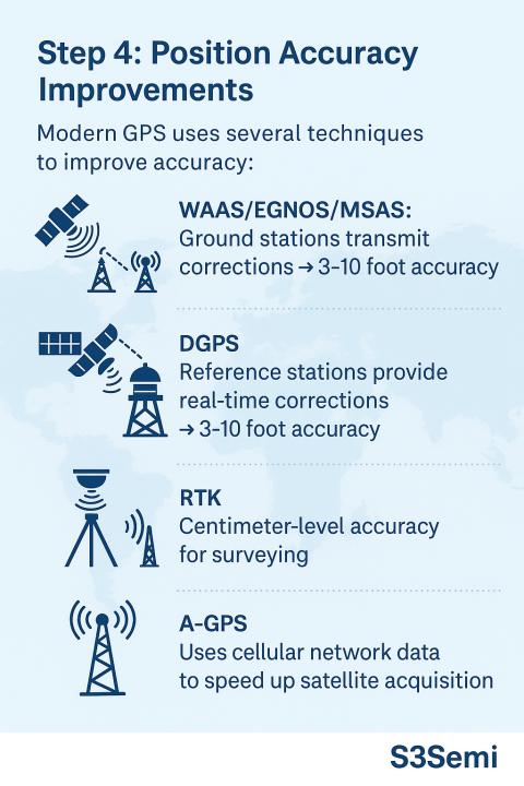
Step 4: Position accuracy improvements
Modern GPS uses several techniques to improve accuracy:
- WAAS/EGNOS/MSAS (Wide Area Augmentation Systems): Ground stations transmit corrections → 3-10 foot accuracy
- DGPS (Differential GPS): Reference stations provide real-time corrections → 3-10 foot accuracy
- RTK (Real-Time Kinematic): Centimeter-level accuracy for surveying
- A-GPS (Assisted GPS): Uses cellular network data to speed up satellite acquisition
🔧 Components of a GPS Tracker
A complete GPS tracker contains several key components working together:
1. GPS Receiver Module
- Antenna to receive satellite signals
- RF (radio frequency) front-end circuitry
- Signal processing chip
- Calculates position from satellite signals
- Power consumption: 20-100 mA active, 1-5 mA sleep mode
- Cost: $5-30 depending on sensitivity and features
Key specs:
- Sensitivity: -160 to -165 dBm (ability to receive weak signals)
- Time to First Fix (TTFF):
- Cold start: 30-60 seconds (no prior data)
- Warm start: 5-15 seconds (some cached data)
- Hot start: 1-5 seconds (recent data available)
- Update rate: 1-10 Hz (positions per second)
- Accuracy: 5-15 feet (1.5-5 meters) typical, 3 feet with WAAS
2. Communication Module
The GPS tracker needs to send location data somewhere – several options:
Cellular (GSM/LTE/5G):
- Most common for vehicle/asset tracking
- Uses 2G, 3G, 4G LTE, or 5G cellular networks
- Sends data to cloud server via internet
- Requires SIM card and data plan ($5-20/month)
- Range: Anywhere with cell coverage
- Power: 100-500 mA when transmitting
Satellite Communication:
- Used in remote areas without cell coverage
- Iridium, Globalstar, Inmarsat networks
- More expensive ($50-200/month for service)
- Larger antenna required
- Marine, aviation, remote exploration applications
Bluetooth:
- Short-range (30-300 feet)
- Used for “item finders” (Tile, AirTag)
- Connects to your smartphone
- No monthly fees
- Works only when near your phone
LoRaWAN (Long Range Wide Area Network):
- Low power, long range (1-10 miles)
- Requires gateway infrastructure
- Good for IoT asset tracking
- Very low data rates
Radio Frequency (RF):
- Custom frequency bands (typically 433 MHz, 900 MHz)
- Short to medium range (0.5-5 miles)
- Used in pet trackers, elderly monitoring
- No monthly fees but limited range
3. Microcontroller (MCU)
- Manages all tracker operations
- Reads GPS position data
- Controls communication module
- Manages power states
- Stores data if connection lost
- Handles sensors (if present)
- Examples: ARM Cortex, ESP32, Arduino-based
4. Power Supply
Battery-powered trackers:
- Lithium-ion or lithium polymer batteries (most common)
- Capacity: 500 mAh – 10,000+ mAh
- Battery life depends on:
- Update frequency (every 10 sec vs every hour)
- Communication method
- GPS sensitivity requirements
- Temperature
- Typical life: 1 day (high frequency) to 6 months (low frequency with sleep mode)
Vehicle-powered trackers:
- Connect to vehicle’s 12V/24V electrical system
- Battery backup for theft detection (vehicle power cut)
- Essentially unlimited runtime
Solar-powered trackers:
- Small solar panel (0.5-5 watts)
- Battery as buffer for night/cloudy days
- Common for marine, outdoor assets
- Good for remote locations
5. Memory/Storage
- Flash memory for storing location history
- Important when out of communication range
- 1 MB can store ~10,000 location points
- Data uploaded when connection restored
6. Additional Sensors (Optional)
Many GPS trackers include extra sensors:
- Accelerometer: Detect movement, crashes, orientation
- Gyroscope: Detect rotation, orientation changes
- Magnetometer: Compass heading
- Temperature sensor: Cold chain monitoring
- Light sensor: Detect if container opened
- Microphone: Audio monitoring, emergency calls
- Geofencing: Virtual boundary alerts (software-based)
🔄 How GPS Trackers Communicate Location Data
Real-Time Tracking Flow
- GPS receiver gets position (every 1-60 seconds depending on settings)
- MCU packages data:
- Latitude, longitude, altitude
- Timestamp
- Speed and heading
- Battery level
- Sensor data (if applicable)
- Device ID
- Data transmitted to server:
- Via cellular: GPRS/LTE data packet to cloud server
- Via satellite: Message to satellite network
- Via Bluetooth: To paired smartphone
- Server processes and stores data:
- Updates database
- Checks for geofence violations
- Triggers alerts if needed
- User accesses data:
- Web browser or mobile app
- View real-time position on map
- Historical track playback
- Reports and analytics
Data Transmission Protocols
GPRS/SMS (2G networks):
- Text-based protocols
- Low bandwidth (10-20 KB/day typical)
- Inexpensive
- Being phased out in many countries
LTE Cat-M1 / NB-IoT (4G):
- Modern IoT-optimized cellular
- Better coverage, lower power than traditional LTE
- Moderate bandwidth
- Future-proof
UDP/TCP over IP:
- Internet protocols
- Efficient, reliable
- Standard for modern trackers
📍 Types of GPS Trackers
1. Real-Time GPS Trackers
How they work:
- Continuously or frequently update position (every 10-60 seconds)
- Stream data to server in near real-time
- Display live position on map
Common uses:
- Fleet management (delivery trucks, taxis)
- Stolen vehicle recovery
- Teen driver monitoring
- Elderly person tracking
- Pet tracking (active mode)
Power requirements: High – need frequent charging or vehicle power
Cost: $30-300 hardware, $10-50/month service
2. Data Logger GPS Trackers
How they work:
- Record position at intervals (every 1-15 minutes)
- Store data in internal memory
- No real-time transmission
- Download data later via USB or when in range
Common uses:
- Personal fitness tracking (running, cycling)
- Wildlife research
- Route documentation
- Evidence collection
- Travel journaling
Power requirements: Low – can last weeks or months
Cost: $50-200, no monthly fees
3. Passive GPS Trackers
How they work:
- Similar to data loggers
- Store location history internally
- Must physically retrieve device to download data
- Common in fleet management (vehicle returns to depot)
Common uses:
- Company vehicle monitoring
- Mileage logging for taxes
- Basic route tracking
Power requirements: Low
Cost: $50-150, minimal or no monthly fees
4. Battery-Powered Personal Trackers
How they work:
- Small, portable devices
- Real-time tracking via cellular
- Rechargeable battery (1-7 days typical)
- Often include SOS button
Common uses:
- Child safety
- Elderly monitoring (dementia patients)
- Lone worker safety
- Hiking safety
Power requirements: Medium – charge every few days
Cost: $50-200, $10-30/month service
5. Hardwired Vehicle Trackers
How they work:
- Professionally installed, connected to vehicle power
- Hidden installation for theft prevention
- Battery backup
- Advanced features (engine diagnostics, fuel monitoring)
Common uses:
- Fleet management
- Stolen vehicle recovery
- Insurance discounts
- Teen driver monitoring
Power requirements: Vehicle powered
Cost: $100-500 + installation, $15-50/month service
6. Asset Trackers
How they work:
- Designed for non-vehicle assets
- Long battery life (months to years)
- Rugged, weatherproof
- Low update frequency
Common uses:
- Shipping containers
- Construction equipment
- Trailers
- Valuable equipment
Power requirements: Very low – extended battery life
Cost: $100-500, $5-30/month service
7. Bluetooth Trackers (Item Finders)
How they work:
- Bluetooth LE connection to smartphone
- No GPS inside – uses phone’s GPS
- Crowd-finding network (other users’ phones detect your lost item)
Examples: Apple AirTag, Tile, Samsung SmartTag
Common uses:
- Keys, wallets, bags
- Luggage
- Pets (very limited range)
Power requirements: Very low – 6-12 months on coin cell battery
Cost: $25-35, no monthly fees
🎯 GPS Tracker Accuracy and Limitations
Accuracy Factors
Standard GPS accuracy:
- Open sky, good conditions: 5-15 feet (1.5-5 meters)
- With WAAS augmentation: 3-10 feet (1-3 meters)
- Urban areas: 15-50 feet (5-15 meters)
- Heavy tree cover: 30-100 feet (10-30 meters)
What affects accuracy:
✅ Improves accuracy:
- More satellites visible (8+ is excellent)
- Clear view of sky
- WAAS/DGPS corrections
- Multi-constellation receivers (GPS + GLONASS + Galileo)
- Good antenna design
- Stationary position (can average readings)
❌ Reduces accuracy:
- Urban canyon effect – tall buildings reflect signals (multipath)
- Tree cover – foliage blocks/weakens signals
- Indoor – can’t receive signals (concrete/metal buildings)
- Tunnels, underground parking
- Weather – heavy rain, snow (minor effect, 3-5 feet)
- Ionosphere/atmosphere – signal delays
- Satellite geometry – poor satellite distribution in sky
- Cheap antenna/receiver – lower sensitivity
Where GPS Doesn’t Work
❌ No GPS signal:
- Inside most buildings
- Underground (subways, mines)
- Underwater (water blocks RF signals)
- Dense forest (very weak signal)
- Parking garages
- Tunnels
Workarounds:
- Assisted GPS (A-GPS): Uses cellular tower triangulation indoors
- WiFi positioning: Uses WiFi networks as reference points (accuracy: 30-300 feet)
- Cell tower triangulation: Uses cellular towers (accuracy: 300-3,000 feet)
- Inertial sensors: Dead reckoning using accelerometer/gyroscope when GPS lost
🔋 Power Consumption and Battery Life
Power Requirements by Component
GPS receiver:
- Active (acquiring/tracking): 30-100 mA
- Sleep mode: 1-5 mA
- Most power-hungry component
Cellular modem:
- Idle: 5-20 mA
- Transmitting: 100-500 mA (brief bursts)
- Sleep: 1-3 mA
MCU:
- Active: 10-50 mA
- Sleep: 0.01-1 mA
Total typical consumption:
- Active tracking (GPS + cellular every 10 sec): 150-300 mA average
- Moderate tracking (GPS + cellular every 60 sec): 50-100 mA average
- Low power mode (GPS + cellular every 10 min): 10-30 mA average
- Deep sleep: 1-5 mA
Battery Life Calculations
Example 1: Real-time pet tracker
- Battery: 1,000 mAh
- GPS fix + transmit every 60 seconds
- Average consumption: 80 mA
- Battery life: 1,000 mAh ÷ 80 mA = 12.5 hours
Example 2: Asset tracker (low power mode)
- Battery: 5,000 mAh
- GPS fix + transmit every 10 minutes
- Average consumption: 20 mA
- Battery life: 5,000 mAh ÷ 20 mA = 250 hours = 10.4 days
Example 3: Extended battery asset tracker
- Battery: 15,000 mAh
- GPS fix + transmit every 1 hour
- Average consumption: 5 mA
- Battery life: 15,000 mAh ÷ 5 mA = 3,000 hours = 125 days = 4 months
Power-Saving Techniques
Adaptive update rates:
- Frequent updates when moving
- Infrequent updates when stationary
- Accelerometer triggers GPS on movement
Smart sleep modes:
- Turn off GPS between fixes
- MCU deep sleep between cycles
- Cellular modem only activates to transmit
Motion-activated tracking:
- GPS and cellular off when stationary
- Accelerometer wakes system on movement
- Can extend battery from days to months
Scheduled tracking:
- Only track during business hours
- User-defined schedules
- Weekend vs weekday modes
🛡️ GPS Tracker Security and Privacy
Security Features
Data encryption:
- End-to-end encryption (device to server)
- TLS/SSL for web/app access
- Protects location data from interception
Authentication:
- Device authentication to server
- User authentication to access data
- API keys for integrations
SIM card security:
- SIM locked to specific networks
- Anti-tamper detection
- Remote SIM disable if stolen
Physical security:
- Tamper alerts (device removed or opened)
- Hidden installations
- Lockable enclosures
Privacy Concerns
Legitimate tracking:
- Company vehicles (employees should be notified)
- Your own property/assets
- Children (with consent of all legal guardians)
- Elderly relatives (with consent if capable)
Illegal/unethical tracking:
- Tracking someone without consent
- Stalking using GPS devices
- Tracking spouse/partner without knowledge (laws vary)
Legal considerations:
- Consent laws vary by jurisdiction
- Workplace tracking usually requires notification
- Tracking minors generally legal for parents
- Tracking adults without consent may be illegal
- Check local laws before deploying trackers
Best practices:
- Be transparent about tracker installation
- Clear policies for employee vehicle tracking
- Secure access to tracking data
- Limit who can view data
- Retain data only as long as needed
- Comply with privacy regulations (GDPR, etc.)
💰 Cost Breakdown
Hardware Costs
| Tracker Type | Typical Cost | Features |
|---|---|---|
| Basic OBD-II plug-in | $25-80 | Simple vehicle tracking |
| Personal GPS tracker | $50-150 | Portable, rechargeable |
| Asset tracker (battery) | $100-300 | Long battery, rugged |
| Fleet tracker (hardwired) | $150-400 | Professional, hidden install |
| Satellite tracker | $300-800 | Remote area tracking |
| Bluetooth tracker | $25-35 | Item finder, no GPS |
Service/Subscription Costs
| Service Type | Monthly Cost | Data Allowance |
|---|---|---|
| Basic cellular (2G/3G) | $5-10 | 5-20 MB |
| Standard cellular (4G LTE) | $10-25 | 50-500 MB |
| Premium cellular (unlimited) | $25-50 | Unlimited, advanced features |
| Satellite tracking | $50-200 | Limited messages/month |
| Bluetooth trackers | $0 | No subscription |
Additional costs:
- Installation (professional): $50-200
- SIM card activation: $0-20 one-time
- Platform access fees: $0-50/month
- API access: $0-100/month
- Multi-device discounts common
🚗 Real-World Applications
1. Fleet Management
How it’s used:
- Track vehicle locations in real-time
- Optimize routes for efficiency
- Monitor driver behavior (speed, harsh braking)
- Automate timesheet/mileage logging
- Reduce fuel costs (10-25% typical)
- Improve customer service (accurate ETAs)
ROI factors:
- Reduced fuel consumption
- Lower insurance premiums (10-30%)
- Increased productivity
- Reduced unauthorized use
- Better maintenance scheduling
2. Stolen Vehicle Recovery
How it’s used:
- Hidden tracker installed in vehicle
- Activated when theft reported
- Police can track in real-time
- Recovery rates: 90%+ with GPS tracker vs 50% without
Advanced features:
- Engine kill switch (remote disable)
- Geofencing alerts (vehicle leaves area)
- Tow detection
- Battery disconnect alerts
3. Personal Safety
How it’s used:
- Elderly with dementia (wandering alerts)
- Children (safe zone monitoring)
- Lone workers (oil field, security, home health)
- Hikers/outdoor enthusiasts
- Emergency SOS button
Key features:
- Two-way communication
- Fall detection (accelerometer)
- Geofencing (safe zones)
- Battery alerts
- Breadcrumb trail
4. Asset Tracking
How it’s used:
- Construction equipment ($50K+ machines)
- Shipping containers (international logistics)
- Trailers (rental companies)
- High-value cargo (pharmaceuticals, electronics)
- Tools and equipment
Benefits:
- Theft deterrence and recovery
- Utilization optimization
- Maintenance scheduling
- Rental fleet management
- Insurance compliance
5. Wildlife Research
How it’s used:
- Track migration patterns
- Study habitat use
- Monitor endangered species
- Research animal behavior
Special requirements:
- Very long battery life (1-3 years)
- Lightweight (for birds: <5% body weight)
- Weatherproof
- Low update frequency (few times per day)
- Often satellite-based (remote areas)
6. Sports and Fitness
How it’s used:
- Running/cycling route tracking
- Performance analytics (pace, elevation)
- Activity sharing (Strava, etc.)
- Training plans
- Safety (share live location)
Devices:
- Smartphone apps (built-in GPS)
- Dedicated GPS watches
- Cycling computers
- Action cameras with GPS
7. Marine and Aviation
How it’s used:
- Vessel tracking (AIS + GPS)
- Aircraft tracking
- Emergency locator beacons (ELT/EPIRB)
- Route navigation
- Collision avoidance
Requirements:
- High reliability
- Satellite backup (beyond cellular range)
- Redundancy
- Regulatory compliance
🔮 Future of GPS Tracking Technology
Emerging Technologies
Multi-constellation receivers:
- GPS + GLONASS + Galileo + BeiDou simultaneously
- Better accuracy (down to 1-3 feet)
- Improved urban canyon performance
- Already common in smartphones, spreading to trackers
Low-power cellular (NB-IoT, LTE-M):
- 10-year battery life possible
- Better building penetration
- Lower costs
- Global roaming
5G integration:
- Higher accuracy positioning (3-10 feet without GPS)
- Lower latency
- Better indoor positioning
- Combined cellular + GPS
AI and machine learning:
- Predictive tracking (anticipate routes)
- Anomaly detection (theft, accidents)
- Behavior pattern analysis
- Automatic geofence adjustment
Indoor positioning systems:
- WiFi RTT (Round Trip Time)
- Ultra-wideband (UWB) – AirTag uses this
- Bluetooth 5.1 direction finding
- 5G positioning
- Accuracy: 3-30 feet indoors
Solar and energy harvesting:
- Integrated solar panels
- Vibration/kinetic energy harvesting
- “Infinite” battery life
- Already in marine trackers, expanding
Smaller, cheaper, more efficient:
- System-on-chip integration
- $5 GPS + cellular trackers possible
- Credit card thickness
- Coin-sized trackers
🔑 Key Takeaways
How GPS trackers work (simple summary):
- GPS receiver picks up signals from 4+ satellites
- Calculates distance to each satellite by measuring signal travel time
- Trilateration determines exact position (latitude, longitude, altitude)
- Communication module (cellular/satellite/Bluetooth) sends data to server or phone
- User views location on map via web or mobile app
Essential components:
- GPS receiver (gets position from satellites)
- Communication module (sends data)
- Microcontroller (manages everything)
- Power supply (battery or vehicle power)
- Antenna (receives GPS signals)
Key specifications to consider:
- Update frequency: How often position updates (every 10 sec to every hour)
- Battery life: Hours to months depending on usage
- Accuracy: 5-15 feet typical, 3 feet with augmentation
- Coverage: Cellular (most areas), satellite (remote), Bluetooth (30-300 feet)
- Monthly cost: $0 (Bluetooth) to $200+ (satellite)
Best use cases:
- Real-time tracking: Fleet management, stolen vehicle recovery, personal safety
- Periodic tracking: Asset tracking, equipment monitoring
- Item finding: Keys, bags, pets (Bluetooth trackers)
Limitations to remember:
- GPS doesn’t work indoors, underground, or underwater
- Accuracy suffers in urban canyons and heavy tree cover
- Battery life vs update frequency tradeoff
- Requires clear view of sky for best performance
- Monthly service costs for cellular/satellite trackers
The bottom line: GPS trackers use satellite signals to determine position, then communicate that data via cellular, satellite, or Bluetooth networks. They’ve become incredibly affordable, accurate, and useful for countless applications from finding your keys to managing fleets of trucks to ensuring elderly relatives are safe.